Uncover Maharashtra’s best-kept secrets: lesser-known forts and caves near the Ajanta and Ellora Caves trail.
Ajanta and Ellora Caves are on every traveller’s must-see list and for good reason. The sublime rock-cut temples and monasteries transport you through centuries of art, faith, and craftsmanship. But while the caves capture all the glory, few realise that the surrounding landscape is a treasure trove of historical forts that are just as dramatic, storied, and panoramic.
So, if you’re visiting Ajanta and Ellora caves and wondering what else you can do to elevate your trip, here are four nearby locations that offer a slice of history, adventure, and local culture, and most of them are within easy reach for a day trip or overnight excursion.
Daulatabad Fort
If you’re visiting the Ellora Caves or exploring the historic lanes of Aurangabad, take a short detour; one that leads you up a hill, through a labyrinth of defences, and into the pages of India’s most fascinating medieval saga.
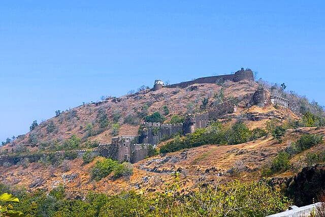
Originally known as Devagiri, meaning “Hill of the Gods,” the fort was built in the 12th century by Bhillama V, a ruler of the Yadava dynasty. It was a flourishing capital, famed for its prosperity and strategic location on a 200-metre-high conical hill with panoramic views of the Deccan.
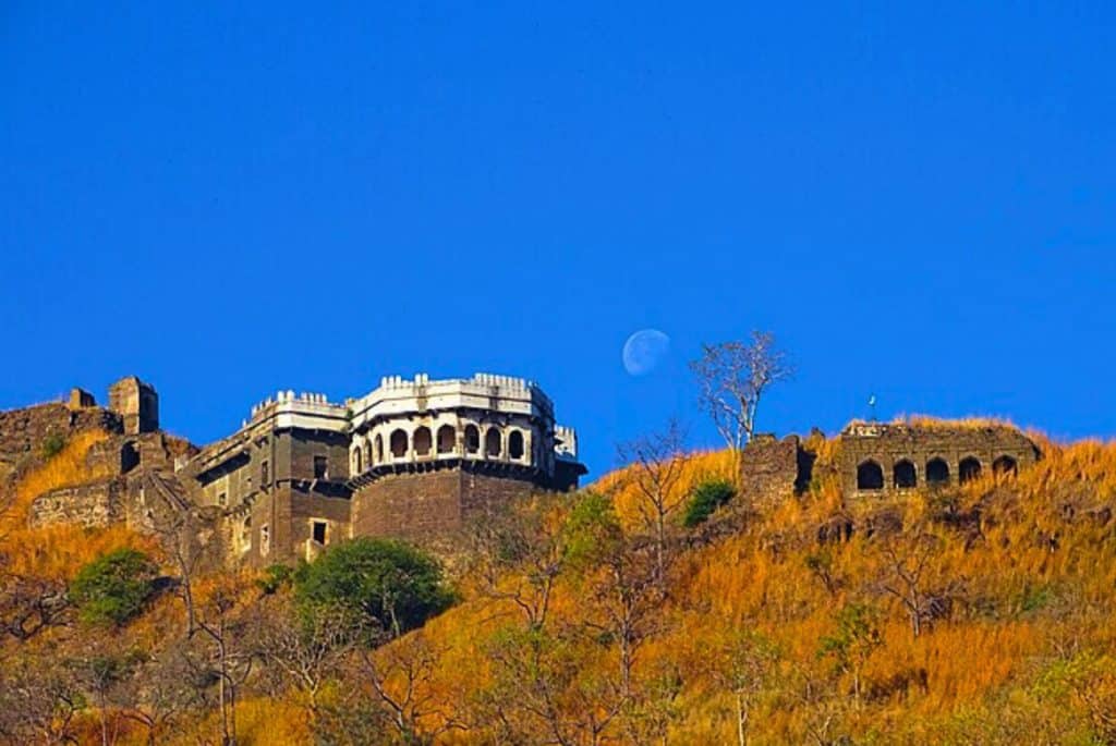
In the 14th century, it caught the eye of the Delhi Sultanate’s most eccentric ruler: Muhammad bin Tughlaq. So impressed was he by Devagiri’s defensible location that he decided to shift his capital there, renaming it Daulatabad, or “City of Wealth.” What followed was a controversial and disastrous mass migration of Delhi’s population southward and a logistical nightmare that ultimately failed, forcing the capital to move back.
Over the centuries, it passed into the hands of the Bahmani Sultanate, the Nizam Shahis of Ahmednagar, the Mughals, and later, the Marathas. Each ruler fortified, modified, and expanded its structures.
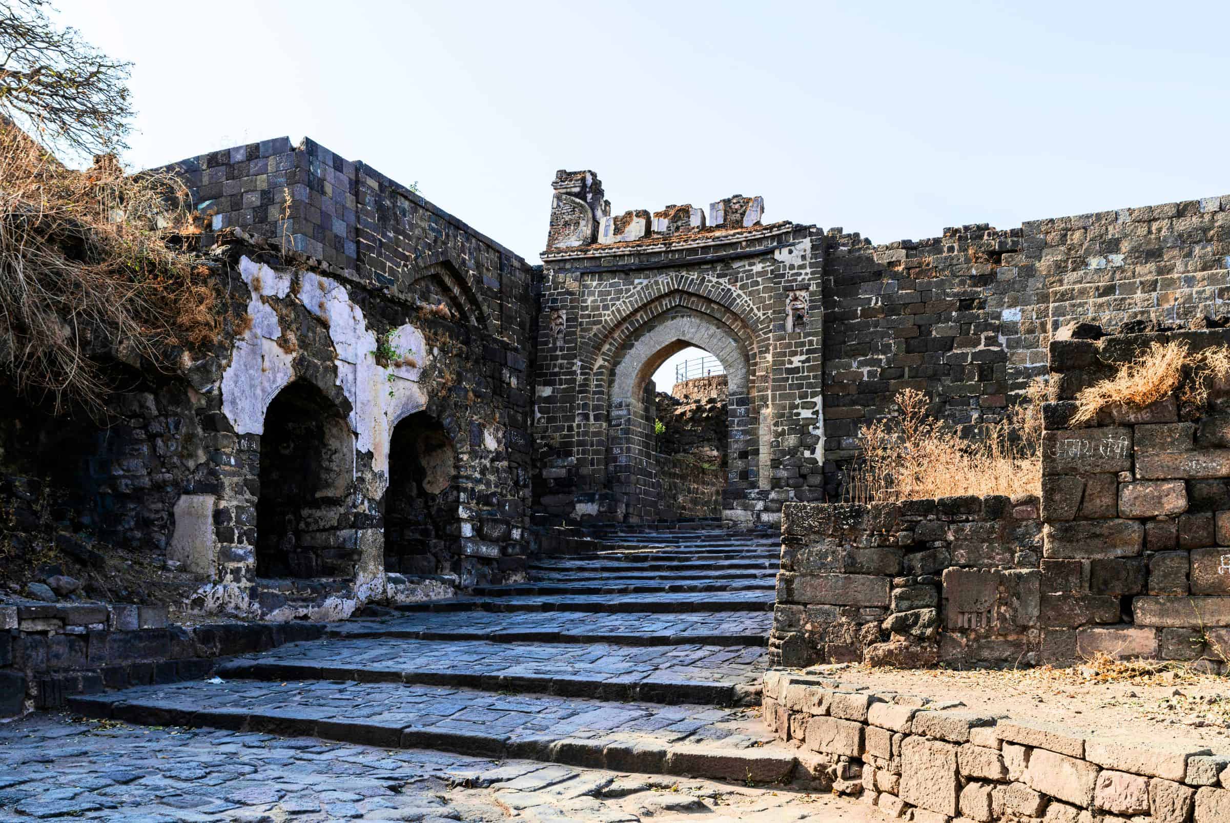
The fort is famous for the Andheri Tunnel, a pitch-dark passage twisted like a maze, originally lit with oil lamps and designed to disorient and trap enemies. It’s narrow, slippery, and was rigged with traps: hot oil, boiling water, and a series of murder holes. Even today, the bats that inhabit it give an eerie feeling as you pass through with a flashlight.
Lesser-Known Facts
Daulatabad Fort was never conquered through brute force; only deceit or betrayal allowed it to fall into enemy hands. Uniquely designed with no parallel entrances, the fort features a single entry and exit point, making both ambush and escape nearly impossible. Its gates and pathways were built with strategic optical illusions—sharp curves and deceptive layouts prevented cavalry charges and funnelled invaders into deadly traps, showcasing the fort’s defensive architecture.
What You’ll See
The Chand Minar, a striking 210-foot-high tower built in 1445 by Ala-ud-din Bahmani to commemorate a military victory, stands as a fine example of Persian-style architecture, echoing the grandeur of Delhi’s Qutub Minar. Nearby, the Baradari, a twelve-door pavilion, offers a panoramic view of the surrounding plains and once hosted royal gatherings. Though much of the palace complex now lies in ruins, the remnants of hammams and living quarters offer a glimpse into the opulent lifestyle of the ruling elite. Scattered across the site are imposing cannons and watch towers, some still intact.
How to Reach
- Nearest City: Aurangabad (approx. 15 km)
- By Road: Easily accessible by road via the Aurangabad–Ellora route. You can hire an auto, or taxi, or drive down NH-52; the road is well-maintained and signposted.
- By Train: The Nearest railway station is Aurangabad Railway Station. From there, take a taxi or local transport to reach the fort.
- By Air: The closest airport is Aurangabad Airport (Chikkalthana), about 22 km away.
- Entrance & Parking: Paid parking is available near the fort entrance; entry tickets can be purchased on-site.
Pro Tip: Combine your visit with Ellora Caves and the Bibi Ka Maqbara for a full-day heritage loop.
Vetalwadi Fort
Tucked away in the Satmala ranges near Soygaon, Vetalwadi Fort remains an unsung hero among Maharashtra’s historic hill forts. Its weathered ramparts may lack the Instagram sheen of more famous sites, but that’s precisely what makes it so magnetic to true explorers.
This 12th-century hill fort sprawls over an impressive 25-acre plateau and is punctuated by 24 bastions, some still standing tall against the winds of time. As you trek upwards, the trail meanders through thick forest, a local temple dedicated to Lord Ganesh, and seasonal waterfalls that breathe life into the terrain. The final stretch offers glorious views of the Soygaon valley, and during monsoon, the hills wrap themselves in green.
It wasn’t the seat of famous dynasties nor the backdrop of dramatic battles, but it stood guard over trade routes and villages for centuries. With minimal crowds, this fort is a haven for trekkers, history lovers, and solitude seekers alike.
Lesser-Known Facts
Spanning approximately 25 acres, the fort is one of the largest hilltop fortifications in the Soygaon region. Despite its impressive size and strategic location, it finds little mention in major historical records, suggesting it may have served as a local stronghold or military outpost. Named after the nearby village of Vetalwadi, dedicated to a local deity believed to protect the hill, the fort carries spiritual as well as defensive significance. Visitors can still spot ancient water harvesting systems and rock-cut cisterns ingeniously designed to ensure year-round water availability.
What You’ll See
The fort is encircled by 24 bastions strategically placed along the hill’s edge, offering panoramic views of the surrounding landscape. Scattered across the site are the ruins of ancient walls and open courtyards, many of which have been partially reclaimed by vegetation, adding a sense of mystery to the terrain. At the base of the trail lies a temple dedicated to Lord Ganesh, still visited by locals and trekkers alike.
During the monsoon, a natural waterfall cascades down the hillside, enhancing both the beauty and the challenge of the ascent. The trek is made even more captivating by rock-cut steps and hidden pathways, all crafted from local basalt stone, revealing the careful planning and craftsmanship of its original builders.
How To Reach
- Nearest Town: Soygaon, Aurangabad district (approx. 100 km from Aurangabad city)
- By Road: Drive or take a bus towards Ajanta Caves, then proceed to Soygaon village. From Soygaon, Vetalwadi village is about 6 km—hire a local jeep or auto.
- Trek Start Point: The trek begins at Vetalwadi village and takes about 45–60 minutes uphill.
- By Train: The Nearest major station is Aurangabad. From there, continue by road.
- By Air: Aurangabad Airport is the nearest airport.
Pro Tip: Trek early in the morning, especially during monsoon, to enjoy the waterfall and avoid the heat.
Pitalkhora Caves
The Pitalkhora Caves have stood carved into the rugged face of the Satmala ranges, quietly shaping the architectural and spiritual legacy of Buddhist India for millennia. Located about 40 km west of Ellora in Maharashtra’s Aurangabad district, Pitalkhora is one of the earliest Buddhist cave complexes in India, dating back as early as the 2nd century BCE.
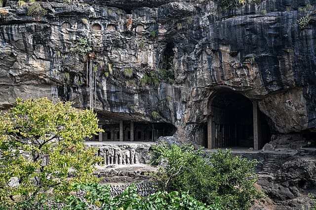
These rock-cut caves are surrounded by a lush, forested gorge where waterfalls descend in the monsoon and mist lingers in the mornings. Also known as “Brazen Glen” due to the metallic tint of the rocks, the name ‘Pitalkhora’ literally means ‘valley of brass.’
The site comprises 14 Buddhist caves, a mix of chaityas (prayer halls) and viharas (monasteries) carved from basalt rock. The most prominent, Cave 3, is a majestic chaitya with 37 intricately carved columns, once capped with a wooden roof now lost to time. The interiors bear traces of sculpted Yakshas, Dvarapalas, and elephants, although erosion has worn down many of the original features.
Though less preserved than Ajanta, Pitalkhora’s importance lies in its chronological primacy. It showcases the transition from simple wooden architectural styles to more elaborate rock-cut forms, laying the foundation for later cave temples across India. The site also served as a monastic hub along ancient trade routes, connecting the Deccan to coastal and northern regions.
A small stream flows beside the caves, and a metal bridge allows safe access across the gorge. Visit during monsoon, and the entire valley comes alive with greenery, the roar of waterfalls, and an atmosphere of serene isolation.
Lesser-Known Facts
Pitalkhora is believed to be one of the oldest Buddhist cave complexes in India, predating even the famed Ajanta and Ellora caves. Referred to as Petrigala in ancient Greco-Roman texts, the site once lay along a significant inland trade route linking Paithan and Nasik to northern India. Among its many intriguing features is Cave 3, which originally had a wooden vaulted roof, with its beam sockets still clearly visible in the stone ceiling. The presence of viharas and chamber-like spaces suggests the site functioned as both a meditation retreat and a centre of learning, making Pitalkhora a vital hub of early Buddhist monastic life.
What You’ll See
The Pitalkhora complex comprises 14 rock-cut caves, including four chaityas (prayer halls) and ten viharas (monastic residences), making it one of the earliest and most complete examples of Buddhist monastic architecture. The caves are adorned with stunning bas-relief sculptures of elephants, Yakshas, Dwarapalas, and other guardian figures, showcasing intricate artistry from the Satavahana period.
Set within a majestic gorge, the site features a monsoon-fed waterfall that often veils the area in mist, adding to its ethereal atmosphere. Visitors can explore the remains of ancient stupas, carved columns, and worn staircases that once echoed with monastic activity. A metal footbridge now leads into the cave complex, enhancing the dramatic approach and offering a breathtaking view of this ancient sanctuary carved into the cliffs.
How To Reach
- Nearest Town: Kannad (approx. 30 km), Aurangabad (approx. 70 km)
- By Road: From Aurangabad, drive toward Ellora, then turn west toward Taleran or Ambala village. A small metal bridge leads into the gorge.
- Last Mile: Walk 1.5–2 km via a narrow trail to reach the caves.
- By Train: Aurangabad Railway Station is the nearest major stop. Hire a cab to the site.
- By Air: Aurangabad Airport is the closest air link.
Pro Tip: Visit in monsoon or early winter for the best views; waterfalls and greenery bring the caves alive.
Durg Bahiri Fort
Hidden in the rugged terrain of the Sahyadri ranges, between Jambhivli and Sandshi villages near Karjat, lies Durg Bahiri Fort. Unlike most hill forts with sweeping walls and expansive bastions, this one is carved into the very face of a cliff.
Also known as Dhak Bahiri, this destination is best known for the Bhairavnath cave temple tucked into a sheer rock wall. The name is derived from the surrounding Dhak peak and the deity Bahiri (Bhairavnath), revered by local devotees. But reaching the shrine isn’t easy; it involves a nerve-racking climb across boulders, rock faces, and vertical ladders, making it one of the most adventurous treks in Maharashtra.
The journey begins with a trail through forests and grassy slopes. As you ascend, the path narrows, and you’ll encounter near-vertical rock patches requiring ropes or metal supports. The final ascent is secured only by a rope and a ladder bolted into a rock face, with sheer drops on either side. This path is not for the faint-hearted, but it is deeply rewarding for trekkers and pilgrims alike.
At the top, the cave shrine awaits. Devotees leave offerings for Bhairavnath, and during annual yatras, the site comes alive with spiritual fervour. The cave also serves as a shelter for trekkers, with a small water cistern and space to rest. The panoramic views of Rajmachi, Bhimashankar, and the Sahyadris make the journey unforgettable.
Though it lacks traditional fort structures like gates or watchtowers, Durg Bahiri served as a natural refuge; its inaccessibility being its greatest defence.
If you’re drawn to places where nature tests your mettle and faith guides your steps, Durg Bahiri is a pilgrimage of both spirit and stamina. Come prepared, respect the climb, and you’ll return with both memories and humility etched into your bones.
Lesser-Known Facts
Named after Bhairavnath, a fierce guardian deity, the fort derives both its identity and spiritual significance from a shrine hidden deep within a cave, accessible only via a near-vertical climb. This challenging ascent was likely an intentional defensive feature, deterring invaders and protecting those within. Rather than functioning as a conventional military base, the fort served as a strategic refuge for local rulers and warriors during times of conflict. Today, its steep and rugged approach has earned it a reputation as one of the most technically demanding climbs in the Sahyadris, making it a popular training ground for seasoned rock climbers.
What You’ll See
The trek begins with a steep, forested trail that soon gives way to sheer rock faces and challenging boulder scrambles. Reaching the hidden cave shrine requires rope climbs and navigating a vertical iron ladder section; an adventure not for the faint-hearted. Inside a rock-cut cavity lies a small but spiritually significant temple dedicated to Bhairavnath, drawing both devotees and trekkers. The summit rewards visitors with breathtaking valley views of Rajmachi, Dhak, and Bhimashankar. During the monsoon, the route transforms with cascading seasonal waterfalls and mist-covered ridges, adding both beauty and drama to the climb.
How To Reach
- Nearest Railway Station: Karjat (on the Mumbai–Pune route)
- By Road: From Karjat, drive or take local transport to Jambhivli village (~12 km).
- Trek Start Point: The trek begins at Sandalgaon or Jambhivli. Trek duration: 2.5–3 hours (challenging).
- By Train: Frequent local and express trains run between Mumbai and Karjat.
- By Air: Mumbai (90 km) and Pune (100 km) are the nearest airports.
Pro Tip: Hire a local trekking guide if you’re not experienced with rope climbs or vertical ascents.
Read More: Latest
